Lutong Ferry
Primary tabs

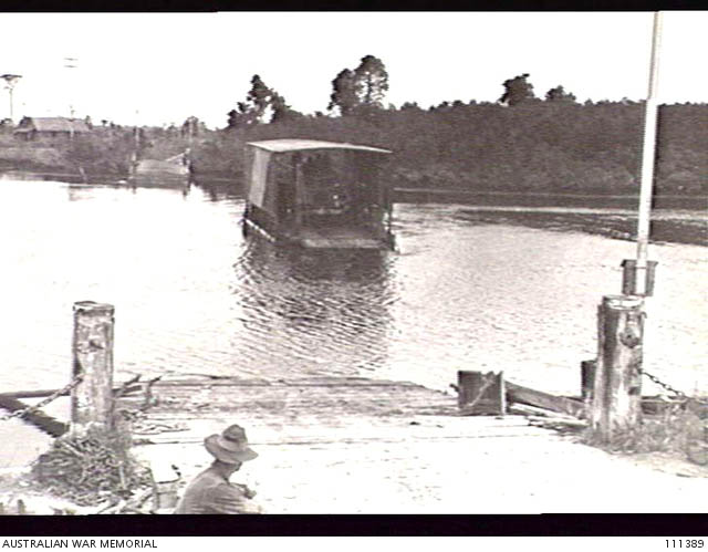

Pictures from Australian War Memorial.
Long before present Lutong bridge was constructed, the area had a ferry service, possibly at or near the site of what is now the Lutong bridge today. These pictures were taken on 4th July, 1945 during the ending stages of the Japanese occupation, by the Australian 2/13 infantry battalion aiming to reoccupy Sarawak from Japanese.
According to some sources, who cited anonymity and mentioned of possible inaccuracy with his information, a previous bridge that had been there had apparently been destroyed in the war, necessitating the need of a ferry to cross. It was possible that this ferry belonged to the armed forces during the occupation.
The photos are described as 'Lutong area' transporting equipment 'across the Miri River to Pujut', suggesting that might possibly be at the curve of the Miri river at the end of Pujut. The background in the second photo does appear to suggest the same general area.
To further scrutinize, the ferry seems to be the same one in the 1975 picture at the river mouth ferry point, minus the canvas roof. This article is from the web site miriresortcity dot com - this sentence is here to prevent blatant plagarism. We can assume the ferry operation later moved to the river mouth where it remained in operation there until at least 1975. Looking at both pictures of the landing ramp carefully shows the two areas are not the same.
 Imperial Palace Hotel is a business class hotel located in Pelita Commercial Center.
 Here are a list of travel and tour agencies in Miri.
 Pujut Corner Market (Tamu Pujut Corner) is located at Pujut Corner, next to the Pujut Corner Bus Station.
 Desa Seri is a residential area located next to Boulevard Commercial Center.